This article is published in Aviation Week & Space Technology and is free to read until Feb 08, 2025. If you want to read more articles from this publication, please click the link to subscribe.

AI-Assisted Infrared Satellites Could Detect Wildfires Within 9 Min.

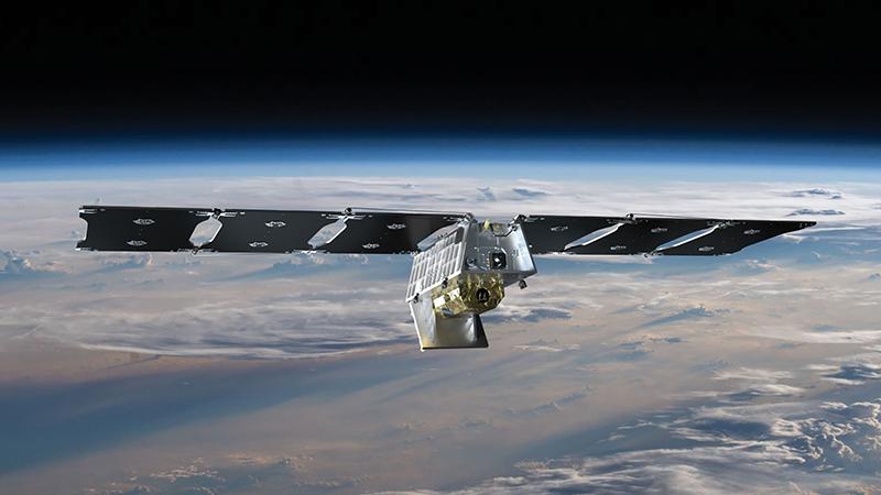
Muon Space satellite

Muon Space raised $56 million in Series B funding in August.

Credit: Muon Space

As global temperatures rise, wildfires are igniting more frequently and in more places than ever before. Stamping out blazes quickly not only saves lives and property but also reduces carbon emissions—the same pollutants that are causing global warming and increasing wildfires in the first place.

Enter the Earth Fire Alliance, an unusual nonprofit venture that is funding the development and launch of a constellation of more than 50 infrared-sensor-carrying satellites to detect and track wildfires within 20 min. of eruption. The FireSat constellation, as it is called, is designed to detect and track wildfires in a smaller area than previous satellites, about 5 m2 (54 ft.2).

  • First test of the FireSat prototype is set for March
  • Multispectral infrared sensor should reduce false alarms

Muon Space of Mountain View, California, is contracted to build the satellites. The company said in May that it plans to start launching operational satellites for the FireSat constellation in 2026. A prototype is scheduled for launch in March 2025.

Muon Space specializes in low-Earth-orbit (LEO) satellites for Earth observation missions, including weather, radio frequency intelligence and agriculture monitoring. The startup announced in August that it had raised $56 million in Series B funding.

Last month, Google said it would provide custom infrared sensors and tailored machine-learning software for the FireSat constellation as part of a development partnership with Muon Space. Google.org, the company’s philanthropic arm, contributed $13 million to the initiative. The Earth Fire Alliance’s other members include the Environmental Defense Fund, the Gordon and Betty Moore Foundation and the Minderoo Foundation.

The constellation would be deployed into LEO, initially comprising three satellites with multispectral infrared instruments to find wildfires. When all 50 satellites are flying, the constellation is expected to revisit certain wildfire-prone areas every 9 min.

The FireSat program aims to detect smaller fires at lower intensities before they grow. To do that without creating false alerts, the Earth Fire Alliance decided to collect data in multiple wavelengths: visible, near-infrared, shortwave infrared, midwave infrared and long-wave infrared.

“The combination of long- and midwave [infrared] allows us to remove false alarms so we don’t just find a hot rock,” Earth Fire Alliance Executive Director Brian Collins tells Aviation Week. “I come from the fire operational world, and providing technology to the fire community, you only get one or two tries if you send a fire department in response to a false alarm.”

Different wavelengths also help detect fires through clouds and smoke while improving firefighters’ understanding of fire intensity, direction and rate of growth.

A constellation of FireSats would allow researchers to observe how fires spread and then develop better prediction models, especially when paired with other information about ground conditions, such as weather, vegetation and terrain data.

Google is lending its computing power and machine-learning expertise to advance fire models. The company has a parallel effort called FireBench, an open-source machine-learning synthetic dataset for wildfire research. Google has also been flying the custom FireSat infrared sensors over controlled burns to validate its machine-learning detection model.

The Earth Fire Alliance initially plans to offer its data free of charge through existing datasets, such as NASA’s Fire Information for Resource Management System and the Global Wildfire Information System, a joint effort among the European Space Agency, NASA and the Group on Earth Observations.

As climate change leads to more intense and fast-moving wildfires, the nonprofit hopes its satellite constellation and machine-learning software can give firefighters a jump on blazes.

“The [fire prediction] models we have, we’ve had for a long time, and they’re great models, but we have some limitations on those models: The compute [requirements are] very high,” Collins says, noting prior limitations on data-processing power. “That’s one of the great things that the artificial intelligence, machine-learning and high-speed data-processing world is addressing: How do we compute at the rate the fire is moving?”

Garrett Reim

Based in the Seattle area, Garrett covers the space sector and advanced technologies that are shaping the future of aerospace and defense, including space startups, advanced air mobility and artificial intelligence.