This article is published in Aviation Week & Space Technology and is free to read until Nov 14, 2024. If you want to read more articles from this publication, please click the link to subscribe.

Special Airport Qualifications Can Minimize Accident Exposure

KSMO airport

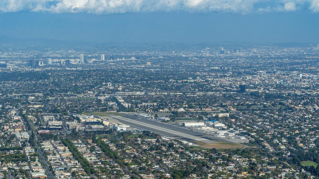
Santa Monica Airport (KSMO) is surrounded by an urban area.

Credit: JJ Withers/Getty Images

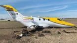
Same story, different day. That could be the tag line for the next deadly general aviation (GA) or business aircraft crash at any one of a dozen U.S. airports with long-term histories of fatal accidents or serious incidents. But a review of National Transportation Safety Board (NTSB) accident records also reveals that it is quite rare for FAR Part 121 commercial airline operators to suffer even minor incidents at the very same airports.

That is mainly because commercial airlines’ safety management systems (SMS) include careful preparation, planning, training and checking their pilots for flying into certain “special areas and airports” as described in FAR §121.445. The regulation requires “special airport qualifications” (SAQ) for pilots in command in the form of initial and recurrent training and checks. Commercial airlines go well beyond the FAA’s basic SAQ requirements, having flight crews and dispatchers pore over weather reports, forecasts and pilot reports (PIREP). They limit the types of aircraft they fly into SAQ airports and assure that no deferred maintenance snags impair approach, departure or landing performance.

SAQs typically include Aspen, Eagle, Gunnison, Hayden, Jackson, Wyoming, plus Mexico City, Guatemala City, Tegucigalpa, Bogota, Quito and Santos-Dumont/Rio de Janeiro, along with St. Maarten, St. Thomas and San Jose, Costa Rica.

Most small GA operators have no such airport-specific risk identification, evaluation and mitigation programs. Some flight departments rely on the experience of veteran aircrews. But should a change in flight crews occur, there is no assurance that the new crews will have the same level of expertise operating at these challenging airports. In contrast, top-tier flight departments, FAR Part 135 charter operators, aircraft management and fractional ownership firms all embrace commercial airline-grade SMS practices for flying into designated high-risk landing facilities.

Accident-Prone Aspen-Pitkin [KASE]

Quite expectedly, this Rocky Mountain destination ranks near the top of the riskiest airports for GA operators, due to its combination of steep final glidepaths, challenging public use instrument approach procedures, mountainous terrain, capricious winds and rapidly changing weather, especially in winter. Typically, aircraft land on Runway 15 with its 1.9% upslope gradient into the box canyon and depart from Runway 33 because fewer terrain obstacles make possible standard instrument departures, albeit ones with considerably steeper minimum climb gradients than textbook 200 ft./nm standard instrument departures (SID).

NTSB records reveal there have been 35 air crashes at Aspen-Pitkin County Airport in Colorado in the last four decades. All 35 have involved GA aircraft. None has involved an air carrier aircraft.

Flying into and out of Aspen is not especially dangerous, but it can be treacherous for the unprepared. Most critically, pilots must prepare themselves and brief their passengers for potential arrival or departure delays, or a possible diversion to an alternate airport.

Attempting to land at Aspen without meticulous preparations can be fatal.

Case in point: In January 2014, a Challenger 601 flight crew, seasoned commercial airline pilots but brand new to the Challenger type, suffered the fatal consequences of not being prepared to fly into Aspen, as documented by the NTSB Aviation Accident Final Report. Neither pilot had more than 14 hr. total time-in-type, including recently completed initial training at a Part 142 facility.

The crew made a host of errors, including not thoroughly briefing the localizer DME E approach, transition to the PAPI visual glideslope indicator, intended touchdown point and landing distance available versus AFM landing distance required, plus not reviewing the missed approach procedure, making plans to divert to an alternate and forecasted weather at the alternate. The localizer DME E approach requires a 6.59 deg. plunge from the final approach fix to Runway 15, so only circling minimums are published even though the approach is aligned with runway centerline, in accordance with FAA TERPS [U.S. Standard for Terminal Instrument Procedures] guidance.

Special Authorization instrument approaches may have shallower approach gradients, but such procedures are restricted to operators that have earned C081 Letters of Authorization from the FAA, as noted by Jason Herman, an airline captain and NBAA-certified aviation manager, who created the Aspen Airport Familiarization Training and Area Briefing guide.

At Aspen, for instance, there is a Special Authorization localizer DME Runway 15 instrument approach with a 4.55 deg. final approach gradient. Earning authorization requires a two-pilot operation, specific crew training and special aircraft performance. To create the procedure, FAA waived several TERPS terrain and obstacle clearance minimums along with a final approach straight-in gradient that exceeds the TERPS maximum 3.77 deg.

Numerous hazards at Aspen are listed in detail in the FAA Chart Supplement including 12,500-ft. to 14,000-ft. mountainous terrain close to the runway, winds and weather that are “amplified” by the mountains, the possible need to plan on diverting to an alternate even when the weather is forecast to be well above charted MDAs and discouraging pilots who are unfamiliar with the airport from operating there during periods of low visibility.

There were several red flags that should have signaled to the crew that attempting an approach and landing at Aspen that day was ill-advised. Seventeen minutes before the<\/p>

Challenger mishap, a Learjet 35 crew broadcast an urgent PIREP, reporting a 10-kt. windshear on a 2-mi. final to Runway 15. Minutes later, a Falcon Jet crew reported a 20-kt. windshear on approach. A Gulfstream G280 crew elected to divert to Rifle 50 nm northwest of Aspen.

Leadville, Copper Mountain and Grand Junction were reporting wind gusts as high as 46 kt. with heavy snow at some locations. Winds, temperatures aloft and stability indices were consistent with mountain wave conditions that produce strong up and down drafts.

Nevertheless, the crew attempted to fly the approach and land. On their first attempted approach, they reported a 33-kt. tailwind and elected to execute the missed approach.

The strong winds were an unambiguous warning to divert. Instead, the crew decided to attempt a second LOC DME-E approach to the airport. Aspen tower reported instantaneous winds 330 deg. at 16 kt. and 1-min. average winds of 320 deg. 14 kt. gusting to 25 kt.—clearly well in excess of the aircraft’s 10-kt. tailwind limit.

Nevertheless, they pressed ahead, attempting to salvage the approach to landing with fatal consequences.

There were several causal factors that led to the accident. First, they did not configure the aircraft for landing, with gear down and full flaps, until midway through the approach passing through 11,000 ft. On the LOC DME E approach, it is essential to configure for landing well prior to crossing the FAF inbound. The lack of drag made it difficult for the captain to control airspeed and altitude while descending on the final approach path. The Challenger AFM permits the use of speedbrakes in the landing configuration at a minimum speed of VREF+10 and down to 300 ft. AGL, enabling the aircraft to be stabilized in steep descents.

Second, the first officer warned the captain that the tailwind was 35 kt. to 39 kt. just outside the final approach fix (FAF). The captain elected to continue the approach.

Once the crew committed to land, inside the FAF, they still were well above the 6.59 deg. glidepath plunge from the FAF to Runway 15.

The Challenger is a Category C aircraft, having normal landing speeds in the 121 kt. to 140 kt. range. NTSB estimated the landing weight of the Challenger at the time of the accident to be 35,881 lb., resulting in a 134 KIAS VREF speed with full flaps according to the AFM. With a 25-kt. tailwind, the 6.59 deg. final approach gradient would have required an 1,860-fpm descent rate from the FAF to the threshold. But the aircraft was well above glidepath, so much greater descent rate was needed to reach the runway.

With a 10-kt. limiting tailwind and assuming a 134-kt. VREF landing speed, the unfactored landing distance would have been 7,000+ ft., not accounting for Runway 15’s 1.9% uphill gradient. According to the FAA Chart Supplement, landing distance available on Runway 15 is 7,006 ft.

The AFM provides no landing distances for tail winds in excess of 10 kt., but extrapolating from the AFM, a full 25-kt. tailwind might have resulted in an estimated landing distance as long as 8,500 ft.

Still, the crew continued the approach. According to the flight data recorder, the captain jockeyed the thrust between 43% and 75% N1, attempting to control the aircraft. Pitch attitude varied between 4.3 deg. nose up to 5.2 deg. nose down. Vertical acceleration reached 2.91G, well in excess of the 2.0G limit with flaps extended. The aircraft never slowed below 140 KIAS.

When the captain finally forced the aircraft onto the runway, it initially bounced between 15 deg. nose up and 13 deg. nose down, then almost 25 deg. nose up before crashing. After the impact, it rolled inverted and finally stopped on the west side of the airport between taxiways A5 and A6, two-thirds down the runway. The impact killed the co-pilot. The captain and jump seat passengers suffered severe injuries.

The Challenger 601 accident could well have served as a wakeup call for business aircraft operators flying into and out of Aspen. Yet, since that January 2014 fatal accident, there have been subsequent mishaps involving a Piper PA-46 Mirage, Cessna Citation 560 Excel, Beechcraft G36 and Hawker 800XP.

aspen airport
Captain Jason Herman has created the Aspen Airport Familiarization Training and Airport Brief guide, a valuable online reference to help business aircraft operators reduce risks when operating into and out of Aspen/Pitkin Airport. Credit: Jason Herman.

Capt. Herman’s Aspen Risk-Mitigation Briefing

Jason Herman was a CE-525B Citation Jet pilot based in Southern California. He is now a Boeing 757/767 captain for a major U.S. airline. During his business jet career, he flew the CJ3 between Southern California and Aspen twice per week in all kinds of weather, taking the time to study the four decades of mistakes made by GA pilots while flying into or out of Aspen that cost them their aircraft and sometimes their lives. NTSB records, available online, provide a half a century of accidents from which to learn from the errors of others.

“You have to be naturally inquisitive, ask lots of questions,” Herman says. “There’s so much tribal knowledge that’s not been documented, some of it correct and some not correct. I vetted it with the airport operator, Denver Center, airport control tower, FBO and other aircraft operators.”

During layovers, he began formal research for his briefing tool. For references, he used ForeFlight 3D Approach Preview and Google Earth, along with studying the FAA Chart Supplement, and both publicly available and Special Authorization instrument procedures for Aspen. He searched for anything that would promote situational awareness and widen safety margins for pilots flying into Aspen.

Herman’s briefing is loaded with photos taken from the CJ’s flight deck and on the ground that clearly depict prominent landmarks, terrain obstacles under and adjacent to the inbound course, and PAPI visual glideslope indicator, plus proximity of the runway to terrain hazards.

Aspen’s localizer DME E approach procedure provides the lowest weather minimums for most business jet operators—Category B [91 to 120 KIAS] and Category C [121 to 140 KIAS]. Cat B minimums are 2,400 ceiling and 3 mi. visibility. Cat C mins are 3,200—3. Herman recommends bumping minimums up to 4,000—5 for safety. Other operators say they raise minimums to 5,000—6 to assure the runway is in sight when their aircraft reach the final approach fix at 11,700 ft. and begin the 6.59 deg., 3,965-ft. plunge to the threshold. Expect a 500 ft. TAWS alert over 9,339 ft. elevation Triangle Mountain if the aircraft is on stable—albeit steep—approach just inside the FAF.

Herman also recommends fully configuring the aircraft for landing at JARGU, the intermediate fix 6.0 nm outside of the FAF to allow adequate time to slow and stabilize the aircraft in preparation for the steep final descent. Other operators say they start to configure the aircraft at the initial approach fix to provide even more time to set up for the approach. The standard operating procedures for configuring jets published in pilot training manuals just do not work at Aspen. The nonstandard SOP for Aspen needs to be rehearsed, discussed and vocalized during the approach.

ntsb crash photo
Credit: NTSB.

If the runway is in sight before the FAF, operators may opt to fly the visual approach. Herman cautions that deviating from the localizer course on the visual approach requires ATC approval. And be wary of the shale bluffs terrain hazard below Cozy Point, south of the localizer and 1 nm from the runway when flying the visual over the Roaring Fork River valley.

Instrument departures from Aspen also can be challenging because they require 460 ft. to 840 ft. per nautical mile climb gradients, well in excess of FAR Part 25 minimums of 2.4% [145 ft./nm] for one-engine-inoperative climb or SIDs 3.3% [200 ft./nm]. The Cozy One VFR Departure is available upon request, if the weather is better than 5,000—5. This enables aircraft departing from Runway 33 to climb in VFR conditions to 13,000 ft. A request to climb above 13,000 ft. automatically activates a pre-filed IFR clearance from LINDZ intersection to the flight plan route.

There are numerous other pointers in the briefing regarding PAPI intercept checkpoints, areas prone to windshear, the balked landing escape maneuver for Runway 15 and a VFR approach procedure he developed for landing on Runway 33, plus traffic management initiatives, “ski country” preferred routes and local operations procedures.

Herman also provides information for nearby divert fields, such as Eagle, Rifle and Grand Junction.

flight chart
Credit: U.S. Government as modified by Fred George.

Embracing FAR §121.445 SAQ For Business Aircraft Operations

Herman’s comprehensive risk analysis and best practices briefing for Aspen provides a useful template for identifying other GA airports that appropriately would be categorized as “special airports and areas” if they were served by scheduled air carriers.

Some top-tier flight departments have long embraced the scheduled air carrier FAR §121.445 SAQ model as an essential part of their SMS. GHA Aviation of Fort Worth, for instance, lists Aspen, Bar Harbor, Eagle, East Hampton, Hailey, Heber Valley, South Lake Tahoe, Santa Monica, Teterboro, Truckee and Washington Reagan as “conditional airports.”

Such landing facilities are identified as “unique due to surrounding terrain, local weather, runway lengths, controlled versus uncontrolled, security, obstructions [and/or] complex approach or departure procedures.” GHA Aviation’s conditional airports document contains specific detailed information for each named airport that must be reviewed, briefed and acknowledged every 180 days by the flight department’s crews. The six-month review includes a comprehensive briefing on VFR and IFR arrival, approach, airport and departure procedures, Jeppesen Airport Qualification and Familiarization Service diagrams, photos and guidelines, if applicable, 3D flight profiles from Foreflight and other resources that identify potential hazards. GHA Aviation flight crews practice flying into and out of these designated conditional airports during recurrent simulator training, much the same as scheduled air carriers rehearse SAQ operations during simulator training.

Bob Agostino, flight department manager at GHA for the past 16 years, believes most Part 142 §61.58 proficiency training is too canned. Agostino also co-founded Bombardier Safety Standdown during his 16-year tenure as head of the firm’s flight demonstration team and senior experimental test pilot.

“You get a false sense of security during the training periods because of practicing the same controlled scenarios. But, during your fourth, fifth, sixth recurrent §61.58 PIC check in the sim, you have extra time to train based upon your good judgment,” he says.

Agostino insists on extra sim sessions for Line Oriented Flight Training [LOFT] that challenge his pilots by putting them in NTSB accident scenarios, changed just enough in time, weather and locale, so that recreating them does not tip off the crew in advance as to what is being thrown at them. The goal is to boost pilot proficiency through LOFT to achieve pilot performance levels as described in FAR §121.903, FAA’s Advanced Qualification Programs regulation.

“After the sim session, we debrief to measure crew performance against the pilots who actually suffered the accident or incident,” Agostino says. He adds that after analyzing several business aircraft accidents, as well as after reviewing pilot performance in the sim, GHA Aviation elected to prohibit circling approaches, except in daylight VFR conditions. He is not hesitant to direct crews to select alternate destination airports when winds, weather, runway conditions and/or obscured terrain makes using conditional airports too risky.

Identifying SAQ Airports

Flight departments can define their own list of SAQ airports by studying adjacent terrain, obstacles and complex approach or arrival procedures, along with winds and weather, at airports they use. FAA’s Airport Assessment Aid, used for determining SAQs for scheduled air carriers, provides a useful template.

Tahoe-Truckee Airport at the north end of Lake Tahoe is one such likely SAQ candidate. The FAA Chart Supplement calls out mountainous terrain surrounding the airport, expected windshear and downdrafts, altimetry errors due to cold temperatures and no aircraft de-icing available. Possible traffic conflicts with gliders, sky diving operations and high-density altitudes during summer months also must be considered. Topping all those factors, NTSB’s accident records are a clear red alert.

Eighty GA accidents have occurred at Tahoe-Truckee in the last four decades, according to the NTSB. The last involved a TBM960 in March 2024. Prior to that mishap, there were fatal crashes of a Challenger 605 in July 2021 and Learjet 35A in December 2005. There also have been numerous crashes of light piston engine aircraft involving hot-and-high departure conditions, flight into known icing and stall/spin loss-of-control mishaps.

The TBM960 accident involved maneuvering following a missed approach on the RNAV (GPS) Runway 20 approach. The ceiling was just 300 ft. above minimums and visibility was three-quarters of a mile, not the 1-mi. minimums needed for the approach. The tower was not in operation, and the VASI was inoperative for Runway 20.

The pilot elected to terminate the approach when Runway 20 was not in sight, then attempted to maneuver the aircraft in visibility conditions as low as a third of a mile in light snow. The pilot turned on and off the autopilot repeatedly while selecting and deselecting both lateral and vertical guidance modes. The ADS-B trace suggests the pilot finally lost control at 280 ft AGL and 170 kt. Both occupants perished in the crash.

The two jet crashes involved loss of control while circling to land in reduced visibility conditions. In the case of the Challenger, visibility was 4 mi. in smoke from wildfires. The crew flew the RNAV (GPS) Runway 20 approach with the intent to circle to land on Runway 11.

This was the first time the captain and first officer had flown together. The cockpit voice recorder reveals a lack of thorough approach procedure briefing, a breakdown in crew resource management, flying the approach considerably faster during some phases of the approach than recommended by Bombardier, improper handoff of controls between pilot flying and pilot not flying and, finally, loss of control due to stall when turning left base to final. Six people lost their lives.

The Learjet 35A crash also involved loss of control when circling to land Runway 28 after flying the west-to-east RNAV (GPS) approach. The aircraft was in and out of cloud bases near the airport. Required visibility for Category C aircraft circling is 3 mi. Reported visibility ranged from 1.5 mi. to 5 mi. Winds varied from 20 kt. to 30 kt. out of the southwest, so there was a significant overshooting crosswind on left base to final Runway 29. Notably, circling is prohibited for Category C aircraft southeast of the airport. The pilot and co-pilot died.

All three crashes indicate that the crews were not fully prepared or adequately briefed to fly the entire approach procedures, including maneuvering to land on 7,001-ft.-long Runway 11/29 or executing missed approaches when attempting to land was no longer safe. All three point to breakdowns in crew resource management. All three suggest that business aircraft operators would be well advised to bump up their own ceiling and visibility minimums, well above charted minimums, before flying into SAQ airports. And all three reinforce the critical need for basic stick, rudder and power management skills while maneuvering at low speed.

Planning And Preparations For SAQ Ops

FAA OpSpec C050, applicable to certificated aircraft operators, is a useful guide for non-certificated business aircraft operators seeking to increase safety margins for operations at SAQs. C050 requires pilots: (1) to have satisfactorily flown into such airports either in actual aircraft or Level D [or better] simulators within the last 12 months; or (2) to have formally qualified by using “pictorial means” within the past year. The latter could include a training course and testing using Foreflight 3D, Jeppesen Airport Qualification and Familiarization Service, instrument procedures charts, topographical maps and satellite imagery. A review of prevailing weather patterns for each time of year is a must.

Prior to the day of the flight, it may be constructive to call the airport manager, FBO, air traffic control tower [if available] and third parties who have experience operating at the landing facility to gain local knowledge about potential risks and ways to reduce task saturation.

A review of instrument procedures charts, topographical maps and satellite imagery, plus a rehearsal of intended flight plan route, circling maneuvers, if required, discussion of landing distance available, taxiway layout between runway and ramp, possible runway contamination and thorough weather briefing are included. “You brief as you’ll fly it. You’ll fly it as you briefed it,” Agostino says. The goal is to eliminate unwelcome surprises, especially ones caused by adverse winds, weather and runway contamination.

Whenever possible, Agostino has his crews practice landing at and departing from GHA Aviation’s conditional airports during FAR 142 recurrent simulator training, after checking all the basic §61.58 boxes. “We want to avoid negative simulator training during which everybody knows in advance what rote maneuver or emergency comes next.”

Just as importantly, Agostino occasionally adds adverse winds and weather and/or contaminated runway conditions, along with a few aircraft abnormalities to the sim scenarios to test crew judgment as to when to tell the principal that they intend divert to an alternate because the risks are too great to attempt landing at the destination.

For example, when Teterboro is forecast to have strong, steady or gusting crosswinds, plus wet runway conditions that would increase the risk of an off-pavement excursion, he expects the crew to inform the principal that they will have to leave earlier for the New York metro area. The recommended destination has been changed from Teterboro to Newark and it will take longer to commute to downtown New York.

The most important risk reduction strategy for SAQ operations is managing crew and passenger expectations for completing the mission. Weigh all the risks, tally the total and decide to go, to delay or to divert. If your SMS does not empower you to say “No, we’re not flying there now” or “We’re not leaving here now,” you are assuming an unnecessary and potentially fatal risk.

Fred George

Fred formerly was senior editor and chief pilot with Business & Commercial Aviation and Aviation Week's chief aircraft evaluation pilot. He has flown left seat in virtually every turbine-powered business jet produced in the past three decades.